

Hanging Lake Trail
Starting Elevation: 6387 Ft
Highest Elevation: 7323 Ft
Trail Length: Officially 2.4 round trip but we probably hit 3.5 ish with all the walking around we did.
Trail Uses: Hiker only
Degree of Difficulty: Officially Strenuous, but it isn’t long, just steep so I will say moderate to difficult. The whole trip took 3.5 hours including gawking time at the top.
Bathrooms: Yes at the parking lot
Pets: No and like super no- if they go in the lake they could ruin the nature of the beauty….
Fees: None

Hanging Lake is one of those things that everyone in Colorado tells you that you have to go and see it in person. Even non hikers have been there, that also means it has insanely heavy traffic all the time and all year round. I had hoped to hit it earlier in the summer so that when my sister came into town I would be able to prepare her better but we celebrated a little too hard after our summiting our first 14er, Quandary instead it was a cancel and recover decision.
This was the perfect hike to experience for the first time with Mary and it was a nice small step up in elevation to help get to some higher hikes in the following days. Unfortunately the weather was not on our side we had initially planned a super early departure from where we were staying in Breckenridge but then I backed off because the forecast changed from rain/snow for the afternoon to the morning…
It was full on blizzard conditions as we drove over Vail pass but turned to super heavy rain as we continued down to Glenwood Canyon. When we pulled into the shockingly EMPTY parking lot, it was just a nice drizzle and there was just one other group of hikers getting into rain gear. We got out and hit the bathroom while deciding what to do, we were there already and it wasn’t pouring anymore so we decided to go for it.


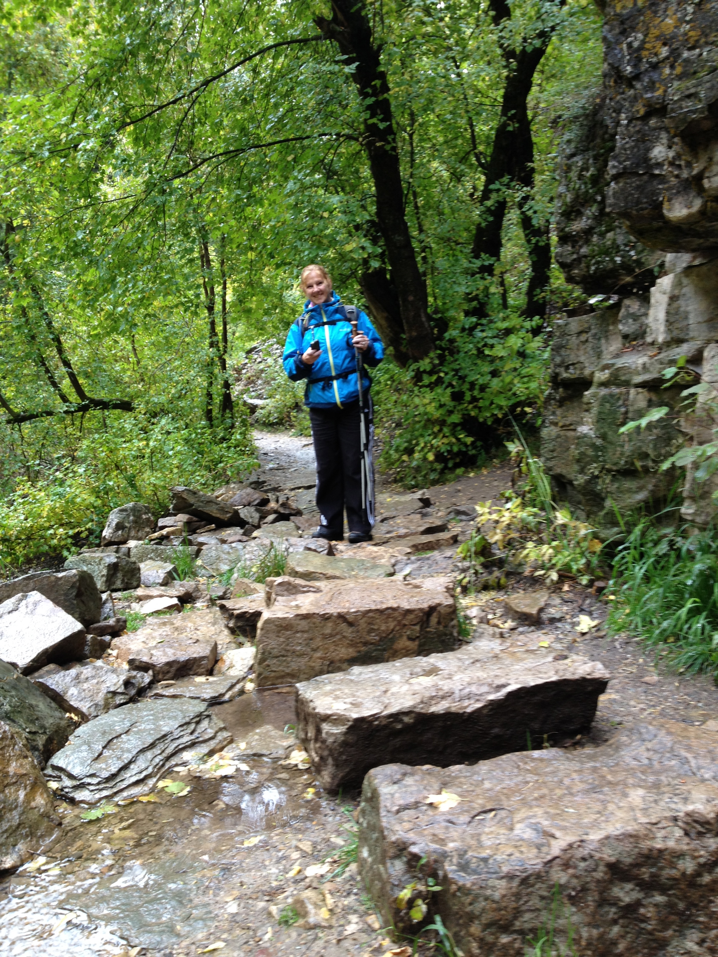
Initially the trail is paved along the Colorado River, and then you get to the trail part pretty quickly and easily. It is 1.2 miles, pretty much straight up with lots of rocks and 5-6 bridge crossings over Dead Horse Gulch. At the end it is so steep that there is a railing to hold onto as you climb up the final rocks to the lake. Which is stunning. I mean seriously.


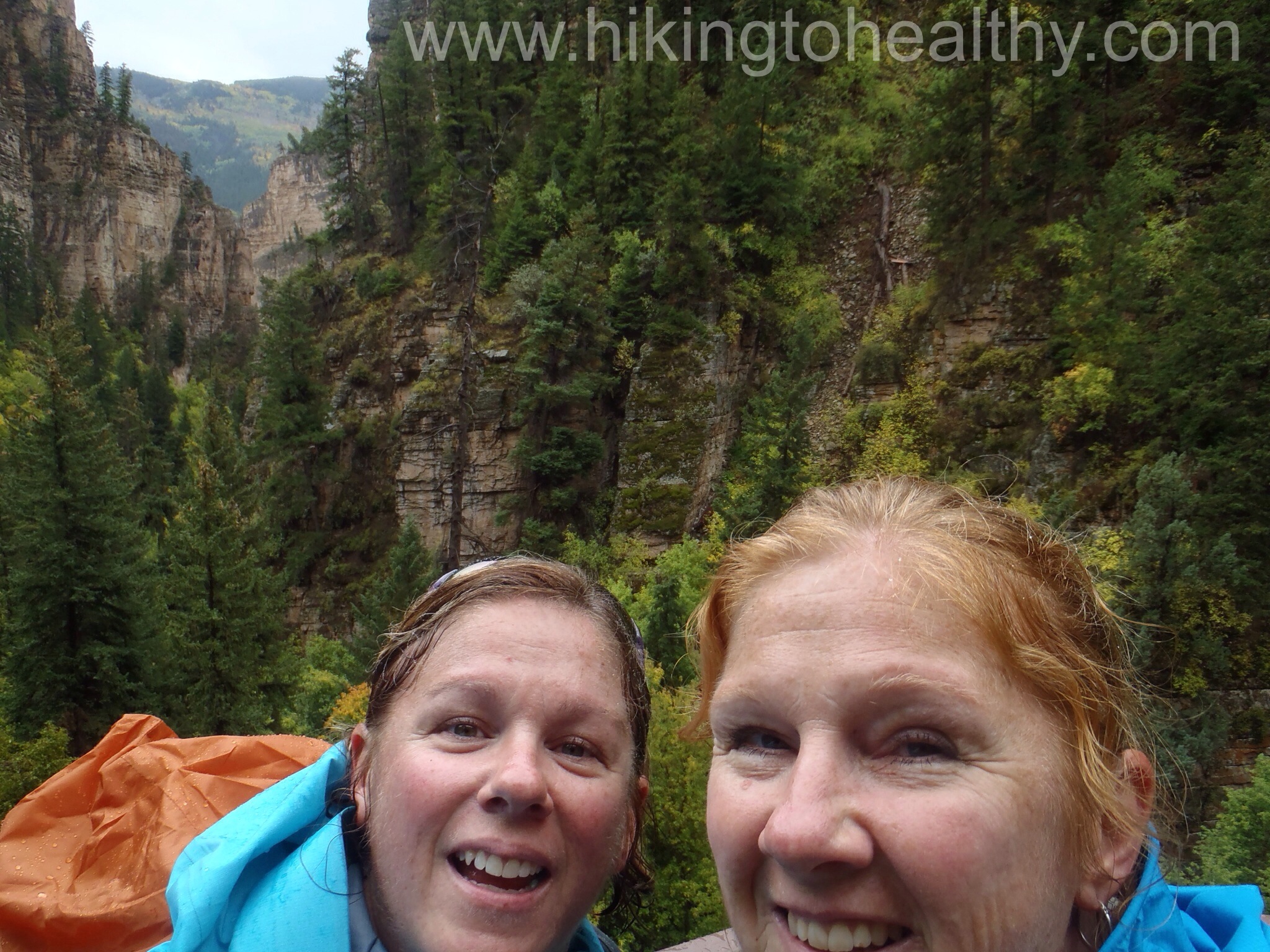
When we got to the final stretch, the railing popped up and the views of the canyon were amazing even in the rain. Mary is “uncomfortable” with heights so when I took this picture she kept saying “careful!” It was cute and there was a very sturdy railing behind us, so unnecessary.


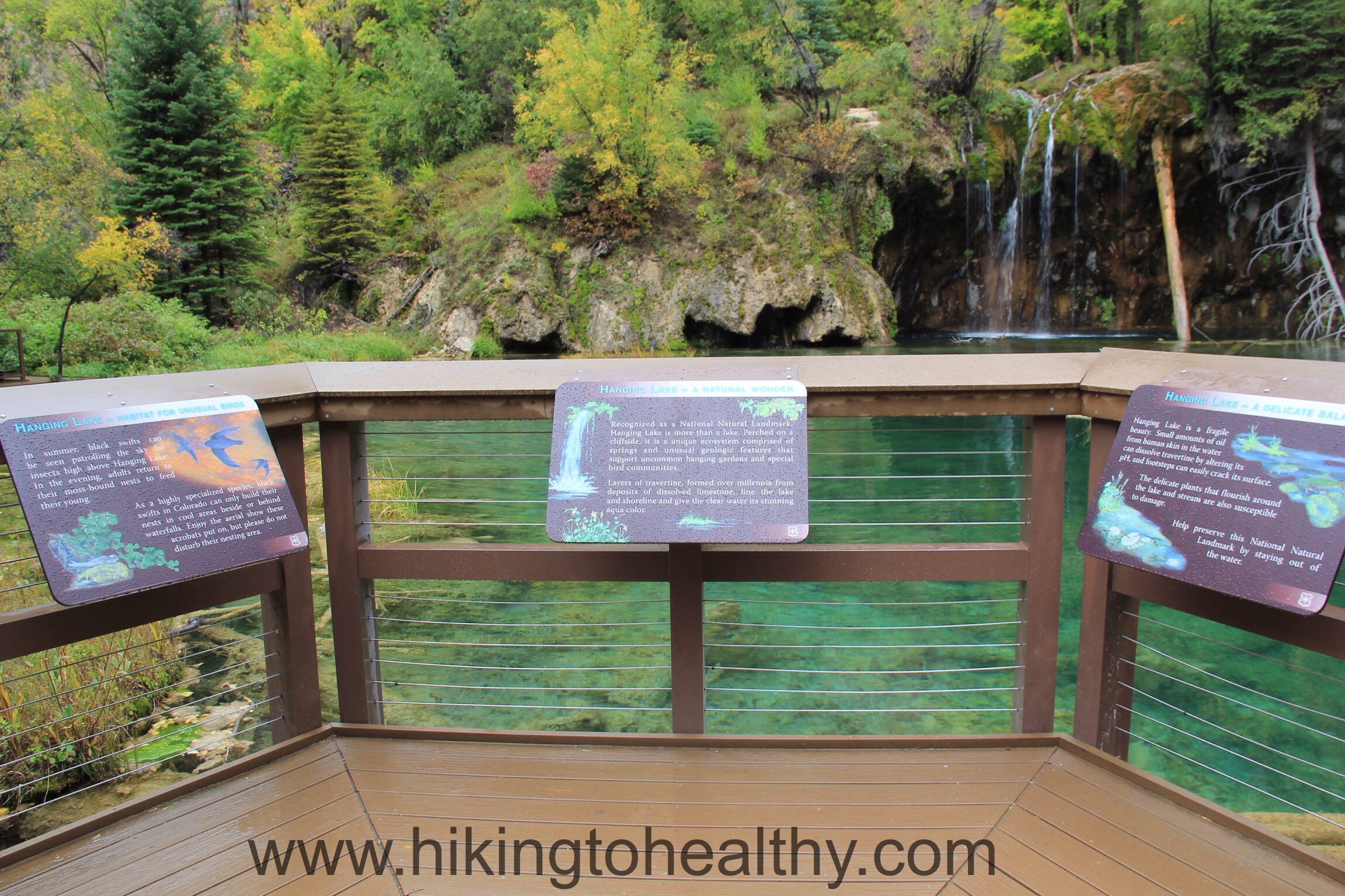
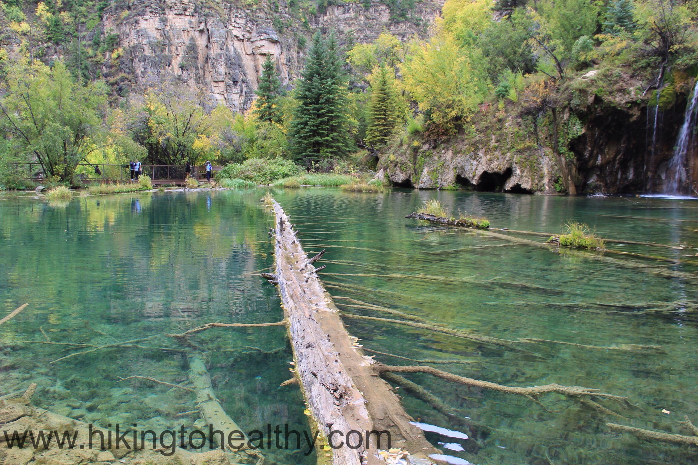
Apparently this is some type of geological anomaly where the travertine deposit under the lake effects the water as seeps through the limestone all around. It creates the most lovely shade of aquamarine regardless of weather…. case in point, it was super cloudy when we were there and the lake almost glowed blue-green through all the gray. It is also incredibly clear and you can see the trout swimming all over the place. In order for this treasure to stay this way, fishing and swimming is strictly prohibited because our body oils would change the composition of the lake and its beauty would evaporate. There is a very nice platform almost all the way around for viewing and signs explaining the rare occurrence that creates this beautiful lake. Plus signs all over saying don’t go in the lake or on the dead tree that slices through the middle, unfortunately people ignore it all the time and if you google it online you eventually see someone walking out on to the log and risking the future of this lake. Every time I see those pictures it hurts my heart, more so now that I have seen it myself.

This place is super crowded all the time, except the day we were there. It was actually perfect, we had the way up mostly to ourselves through some drizzle and when we got to the top the rain stopped long enough for us to get some great pictures and then it started up again as we headed down. It also started to get more crowded but nothing like what I have read, it was actually pretty magical.
It was also interesting to watch the differently prepared groups of people hiking up….people in shorts and tank tops – it was maybe 45 degrees out and raining. The 2 motorcyclist carrying their helmets up totally not dressed for hiking, pretty sure they turned around after we told them they weren’t quite halfway up…. I must learn to lie better in those situations. People climbing up in keds, it is the short distance and that tricks so many. It is still a tough hike so make sure you prepare like you would for any alpine hike. After the directions are a few more pictures. I cannot wait to bring more people to Hanging Lake, we loved it!
Directions: Hanging lake is in Glenwood Canyon , just before you reach Glenwood Springs. You can only get to it from the East bound side of I70 and if the parking lot is full, then you need to drive around and keep checking for a spot or come back another day. Seriously no parking spot no hike. This also means if you are coming from the East, you have to drive 5 miles past and then double back to get to the trailhead. Travel 22 miles west of Eagle on I-70 to the Grizzly Creek exit in Glenwood Canyon.After exiting, get back on the highway going eastbound to the Hanging Lake exit.The trail begins 1/4 mile east of the rest area on the left just before the bridge.


It looks so beautiful there! I think I’ll be adding it to my list of hikes for next year!
You should, it is amazing!!!!
Very cool!
so much better in person
Oh you went to hanging lake!!! On my list…I hear it is beautiful!
It really is super beautiful!!! Go during the week if you can I have heard it is insanely busy!
Isn’t that a great hike! A little oasis that you’d never expect in Colorado.
It was just amazing!!! I mean WOW!
I love the details that you provide! And the pics! Beautiful hike.
Thanks! The lake is just amazing I am not sure my pics give it justice!
Then I’ll just have to hike it for myself one day 🙂
Awesome post. We intended to do this hike this year, but…..life got in the way. Thanks for sharing.
You have to make your way there eventually! It really was unbelievable in person.
Just beautiful! Adding to my list!
You really must!!! It was spectacular in person!!! The color is wild!
How did I miss this post? This hike looks breathtaking!
It really was! One of the best payoffs for a climb ever!
Thank you for this post. It looks so beautiful. Has a photographer I can’t wait to do this hike. but still need to get in better shape. It is on my bucket list for late spring or early summer – CLG